1893, 1910, 1936 maps - development
1893 - Bolton and St Helens Trust Turnpike is now St Helens Road. Most turnpikes were discontinued by a series of Parliamentary Acts between 1873 and 1878. (At the peak in 1830 there were over 1000 trusts administering about 30,000 miles of road with about 8000 toll gates. Note the word “Tramway” and the indication of tracks which seem to stop just short of the level crossing.
[[The Daubhill tramway was extended to Four Lane Ends on 19 July 1906 (how did the train tracks and the tram tracks cross each other?). On 14 June 1909 an agreement with South Lancashire Tramways (Transport from 1929) provided a route from Bolton through Leigh and Atherton to Lowton. The through service operated by S.L.T. trams to Leigh was replaced by trolleybuses in December 1933, although Bolton trams still ran to the borough boundary at Four Lane Ends until March 1936, when they too were replaced by S.L.T. trolleybuses. Trams in Bolton finally ceased on the 29th March 1947 with the closure of the final section to Tonge Moor, performed by suitably decorated car 440. (http://www.petergould.co.uk/local_transport_history/fleetlists/bolton1.htm)]]
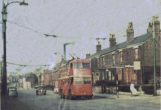
Trolley bus to Leigh on St Helens Road just west of Daubhill Station
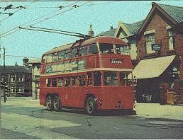
Trolley bus to Leigh on New Brook Road at Four Lane Ends
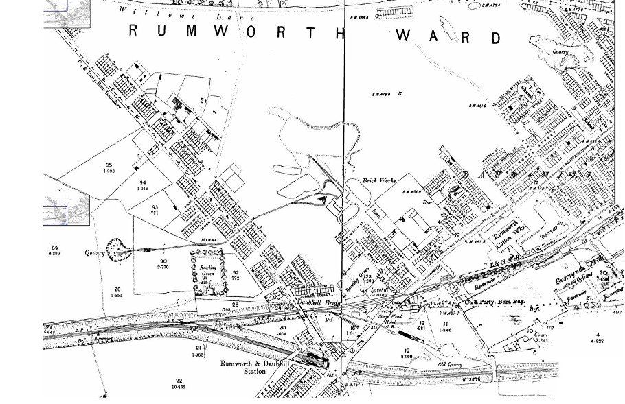
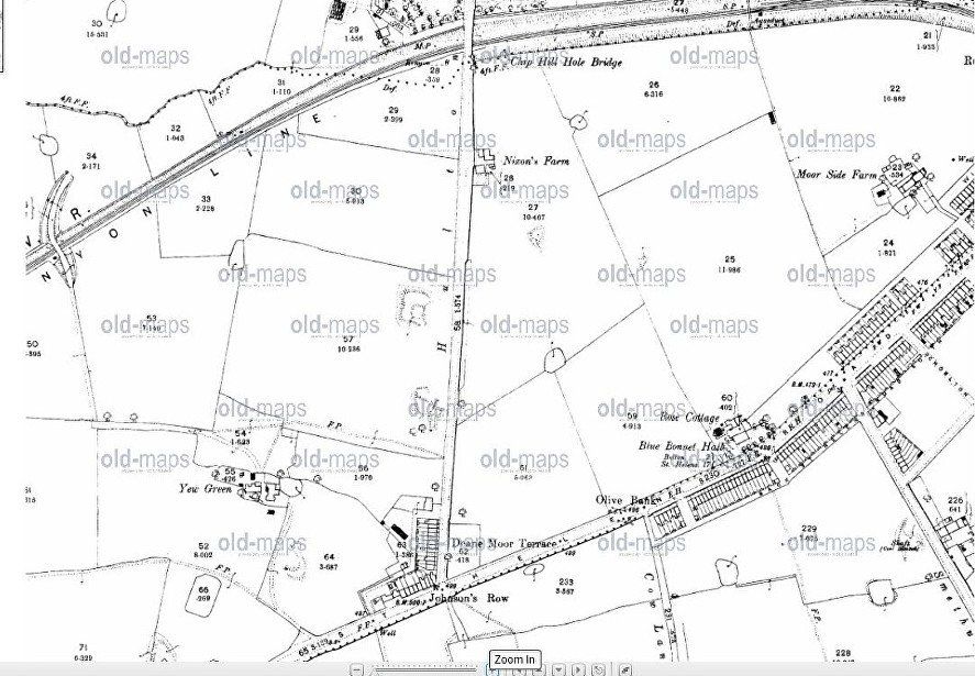
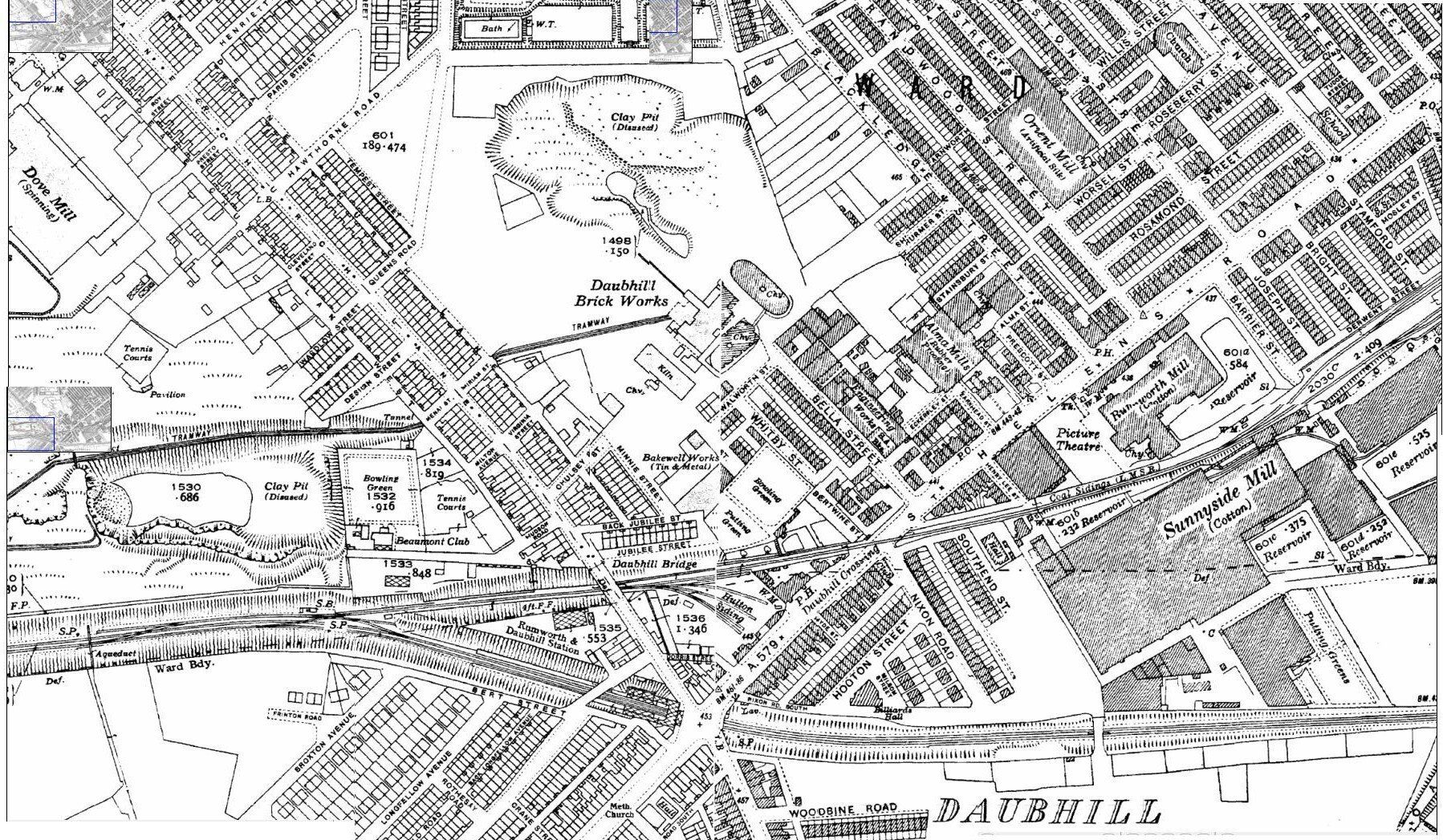
The above maps are 1893. The top one is above and to the right of the bottom one. Rumworth and Daubhill Station near the bottom and left of centre on the top map matches with Ru at top right of the lower map.
The brick-works is at the top of Bella Street with its original clay pit just above connected by a “tramway” to a quarry west of Deane Church Lane. Although the tramway was long gone, the quarry was visible (rather bigger than on this map) in the 1950s. It became a corporation land fill site, still in use until 1970 or just after and was then grassed over in which state it remained until building of a new estate commenced in 2021. There was a footpath between the quarry and the railway from Hulton Lane to Deane Church Lane locally called the “switchback” (if you rode your bike along it you found out why). The footpath was separated from the railway by a fence of old railway sleepers, clearly seen as a black line on a number of old photographs.
There is now a considerable amount of building north of St Helens Road but Randal Street ends at, and Venice Street is cut in half by a quarry. St George the Martyr’s is marked as “Church” but there is no housing yet between it and Willows Lane.
Rumworth cotton works (in recent years the Lantor building and now 2017 Stirling) and Sunnyside mills are marked.
The original railway line stops at Adelaide Street. The railway can be seen in its new (1885) position.
There is building along Deane Church Lane but no Nixon Road or Hooton Street and no Woodbine Road on the Morris Green side of the railway. The co-op on the corner of Woodbine Road and Morris Green Lane has not yet been built.
There appears to be another level crossing west of the Stag’s Head.
Jubilee Street overlooks the railway. This implies that the terrace was built in 1887 at Queen Victoria’s Golden Jubilee (obviously not the diamond jubilee in 1897!)
Wightman Street later becomes Longfield Road.
Notice the Haynes Street shuttle works.
West of Daubhill Station:- housing on the north side up as far as Smethurst Lane, on the south side as far as Cow Lane. Note the terrace names (plaques are still visible) Olive Bank, Deane Moor. Notice Blue Bonnet Hall which we have mentioned elsewhere (Daubhill - the place to live).
Milestone on the bend (near Blue Bonnet Hall), Bolton 2 1/4 St Helens 17 (The official length of the Bolton and St Helens Turnpike was 17 miles, 2 furlongs and 44 yards not the full distance between the towns – in Bolton it started at Willows Lane where Derby Street becomes St Helens Road.)
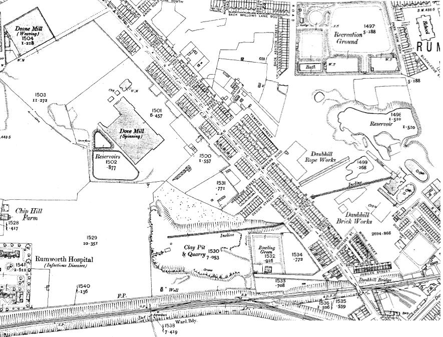
The above maps are from 1910
Booth’s Steel works are now marked. These continued to function until the 1970s.
St Helens Road is now built up either side just beyond Hulton Lane. Hulton Lane has just the top two blocks on the east side (that is the Bolton side, the other side is Westhoughton). Longfield Road is only built on the south side and only up as far as Henry Herman Street. There is still no building on Smethurst Lane and on St Helens Road there is a gap above Lister Street.
Moorside Road leads to Moor Side Farm. (The farm is no more and the road is now Edge Hill Road.}
Haynes Street Mission is marked in its original position before it moved to Aldred Street. The Co-op seems now to have been built at Woodbine Road which has the terrace at the south side but not yet the semis against the railway. Morris Green Lane is built up and the older part of St Bede’s School is marked.
What is now Nixon Road is marked as Beaumont Road and the little back street along the north side of the railway appears to be Beaumont Road South. Hooton Street exists but not Milsom Avenue. The terraced houses in Southend Street have now been built.
Brandwood Street School has been built but the houses on Brandwood Street and Blackledge Street seem to be incomplete. Dijon Street has now appeared but only houses on the odd numbered side (left going up) have been built so far. The Brickworks is functioning with its clay pit, marked as reservoir close by (This was known as the shale hole by the locals in the 1940s 1950s) and the “incline” and tunnel to the quarry on the other side of Deane Church Lane.
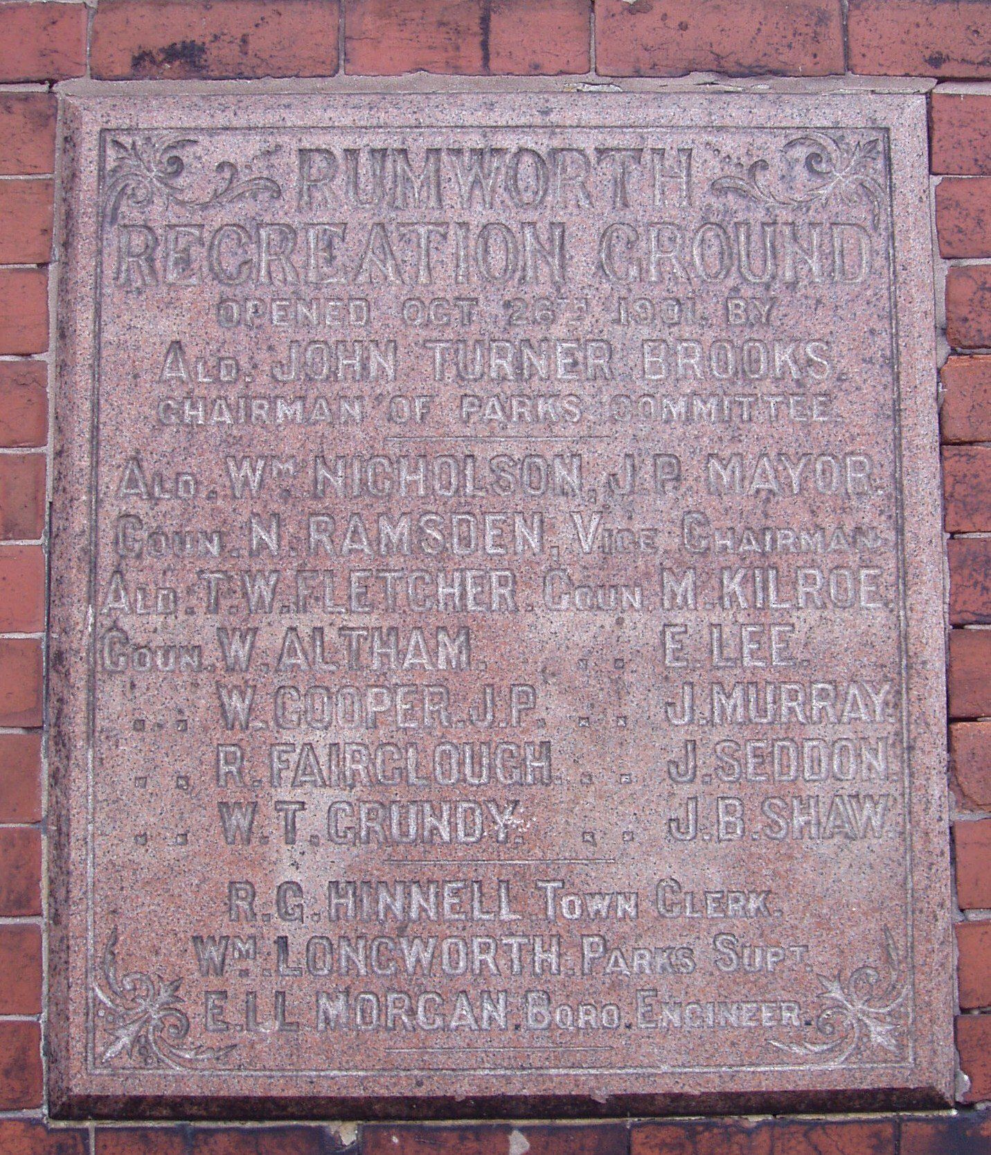
Rumworth Recreation Ground can be seen with its swimming pool. Picture above of the plaque commemorating its opening 26th October 1901 was mounted on the rear of the shelter at the back of the swimming pool and is still visible on Hawthorne Road. The pool was still there in the early 1950s I never saw water in it though some people have told me that they did.
There are no signs of the Daubhill Athletic football ground south of Rumworth Park (it probably covered part of the clay pit) or of Lomax’s FC behind Woodbine Road.
Note the Daubhill Rope Works on Deane Church Lane.
The Daubhill Zion Methodist Church is marked as “chapel” just up from Daubhill Station.
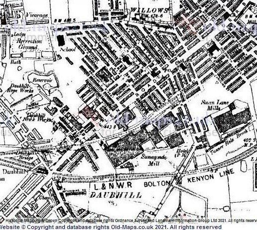
1936 map
The Majestic cinema is marked (as Picture Theatre) and the Billiard Hall in Hooton Street has now appeared. Nixon Road which was still Beaumont Road in 1930 now has its current name. The Daubhill Zion Methodist Church has become “church” instead of “chapel” with "hall" next to it.
The Holiness Tabernacle (now Church of the Nazarene) has appeared on Southend Street as "Hall".
The railway tracks into the Daubhill coal yard are marked as Hulton Siding.
Some building of semis has taken place in Broxton Avenue and Frinton Road but this is not complete.
Orient Mill, whose owner lived in Orient House on Wigan Road, has the label "Artificial Silk". I remember this Mill being known as Klondike.
Milsom Avenue has been labelled as Milsom Street.
On the next page we look at 1900 onwards - housing