1878 St Helens Road 1885 The Railway
1878 St Helens Road
By 1878 all turnpikes had been discontinued by Act of Parliament. The Bolton and St Helens Turnpike became the responsibility of the local council and was renamed St Helens Road.
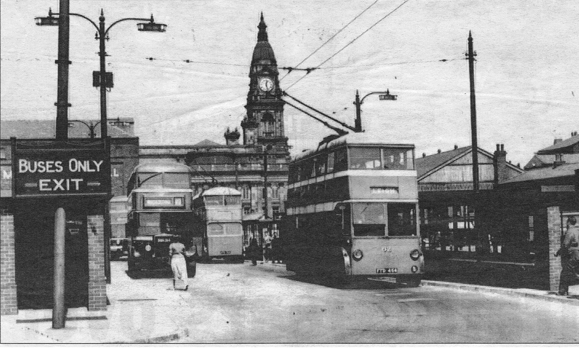
<<<< 1950s Trolley bus at Howell Croft South about to come "up Dobble" on its way to Leigh. (Clip from Bolton Evening News)
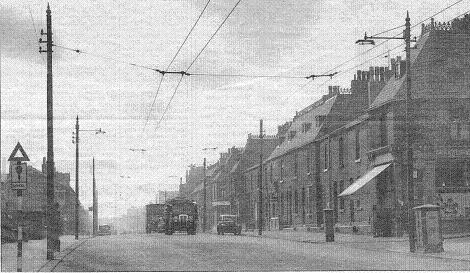
Derby Street, looking towards St Helens Road, 1956
Derby Street becomes St Helens Road at Willows Lane, the street on the left between the Railway Hotel and "Handy House".
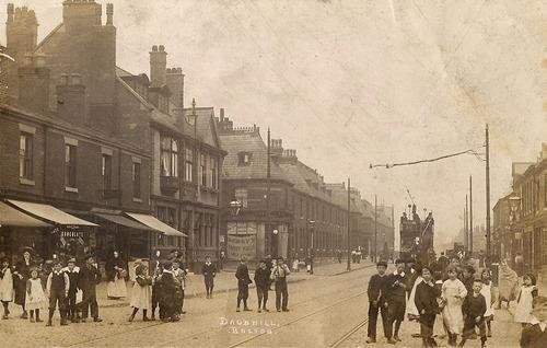
Old post card of c1905
1885 The Railway Rerouted
The need to haul trains up the 1 in 33 gradient to Adelaide street by cable and stationary winch was hardly satisfactory and so a new route behind Sunnyside Mills was planned which went all the way into Bolton with much less gradient. The final decision to create this line may have been hastened by "runaway trains" losing control on the incline and crashing into the coal yards in town. On 28th January 1858 an engine lost control on this gradient and crashed through the buffers at Great Moor Street station causing substantial damage. By the time the new railway was opened new locos were strong enough to get up the incline without the rope and in fact the most serious runaway train incident was later and on the new line. The new line still had a gradient of 1 in 34 but for a much shorter distance than the original 1 in 33 “inclined plane”.
This image has been reproduced on the end gable of the Sweet Green Tavern which is very close to the site of the accident.
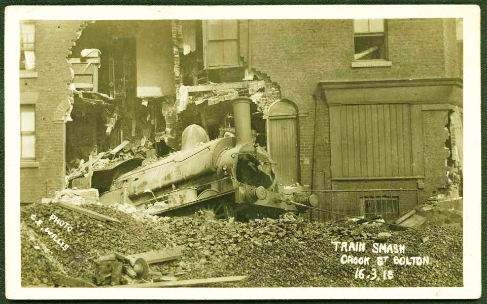
http://www.railwaysarchive.co.uk/documents/BoT_BoltonCrookStreet1918.pdf
The accident to a coal train, which happened on the 16th March,(1918) about 11.15 p.m., in Crook Street Goods Yard, Bolton, on the London & North Western Railway.
In this case a special coal train from Hulton Sidings, when approaching Bolton Terminal Station, got out of control. It was turned into one of the lines in the goods yard (Crook Street), ran through the yard on the metals, forced its way through the boundary wall, crossed the public road diagonally and completely wrecked two small dwelling-houses. The guard jumped from the brake-van ; the driver and fireman remained on the footplate. None of the men suffered more than minor injuries.
Eight persons living in the houses were injured, though fortunately not seriously. In addition to the damage to the engine and house property, five wagons were demolished and seven others damaged. (short extract of the long report)
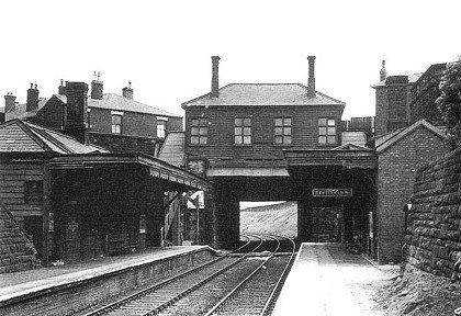
The railway entered a deep cutting and went under St Helens Road, a station being built in the NW corner of the road junction of St Helens Road and Deane Church Lane with steps from either side to reach the two platforms.
When the new line was opened, the old line was retained from the diversion north of the station (west of Deane Church Lane), under Deane Church Lane (marked as Daub Hill Bridge on the 1849 map) as far as Adelaide Street and it delivered to a huge coal yard (picture below) just off St Helens Road, below Jubilee Street, where ASDA (previously Netto) is now. Then, across the level crossing it delivered to a couple of other coal merchants and presumably also supplied the mill itself. It would be almost certain that their supplies of raw cotton would continue to come in this way too.
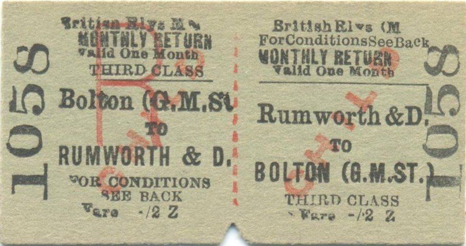
Ticket from the collection of Steven John Parker
Used with permission.
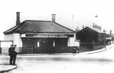
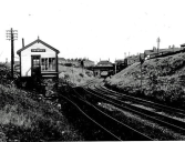
1949 Daubhill Station and Deane Church Lane,
posted on Facebook - "I belong to Bolton" by Andrew Hodson >>>>>>>>>

1. Rumworth and Daubhill Station in 1952 looking along the lines, open and functioning posted on Facebook by Steven Buckley
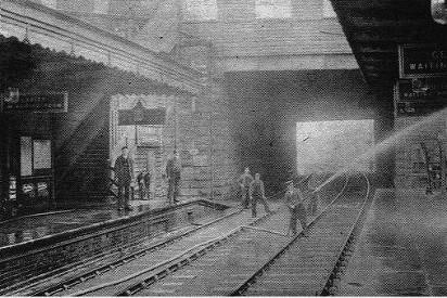
2. probably 1950 Daubhill Station looking along the lines, open and functioning, man with hose-pipe
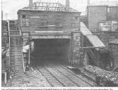
3 and 4. Daubhill Station in process of demolition while the line is still in use, 1955. The Station had closed in 1952.
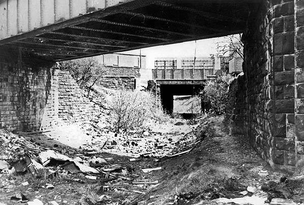
1. 24Oct1978 picture from Tom Openshaw; the nearer bridge is at the bottom of Longfield Rd; the further bridge is where Daubhill Station had been, on the left corner of Deane Church Lane.
2. View from behind station with Deane Church Lane on the left, looking towards Morris Green. The station has been removed and in-filling the cutting will begin later. Picture posted on Facebook by Stephen Southern.
3. 1952: 150 yards behind Rumworth and_Daubhill. At this point the original, 1828, line goes straight on to the Daubhill level crossing, Sunnyside Milis and Daubhill coal yard while the 1885 diversion swings right to go under St Helens Road at Daubhill Station
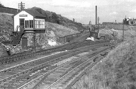
4. Daubhill signal box and junction between the 1828 and 1885 lines. To the right the bridge you can see is Longfield Road, the station sits atop of the St Helens Road bridge about 30 yards further on.
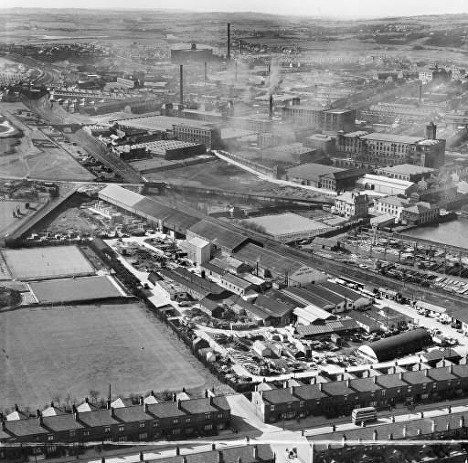
The realigned (1885) double track railway. Top left on the S bend is the junction of the original line and the new line. Then the St Helen's Road bridge where Daubhill Station was. There is a bridge which didn't really go anywhere then clearly Ellesmere Road bridge with its long inclines either side. Behind Ellesmere Road on the left are the hen pens down from Woodbine Road (the originally built part from Morris Green Lane). Behind it on the right you see Dove Mill in the distance and closer the huge Sunnyside Mills complex and at the bottom of the incline is the Sunnyside Hotel, now a residential home. In the foreground is Sunnyside Park and the Townson site with Higher Swan Lane running across the bottom.
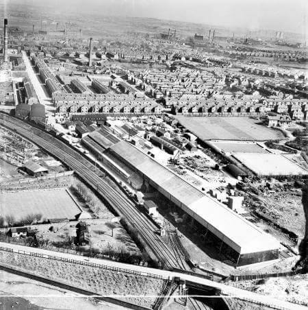
Ellesmere Road bridge at the bottom with Townson's to the right of the railway. The picture on the left looks away from town towards Daubhill and the above picture is looking towards Bolton.
Looking south east (away from Daubhill) towards the Ellesmere Road Bridge. Sunnyside Hotel, Swan Lane Spinning Mill, Townson’s are all visible.
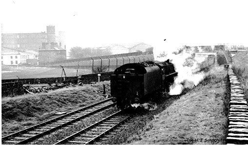
(C)1966 H J Scowcroft.
Ellesmere Road bridge on the Bolton side.
Visible are Rutland Mills, Sunnyside Hotel and Swan Lane Mill
Posted on Facebook by Edward Thompson.
Apologies to the initiator of this picture, I do not seem to have a note of who you are.
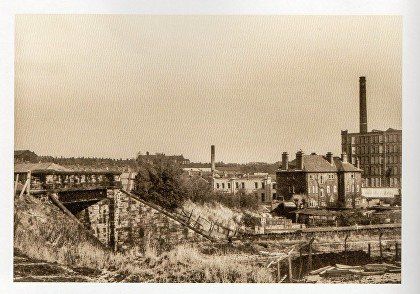
A fantastic blast from the past for any Dobble-ites who used to play on this waste land between Woodbine Road, the railway and Nixon Road.
Front left, the hen pens, then the railway bridge that was never a real route and whose surface was just rough rocks. The new telephone (BT) building can be seen at the left. Then Sunnyside Mills. Swan Lane Mills and the Rutland Mills building are at right with the Sunnyside pub and Ellesmere Road just off picture. Behind and to the right was Lomax's football field though by this time it was probably occupied by Evans waste paper.
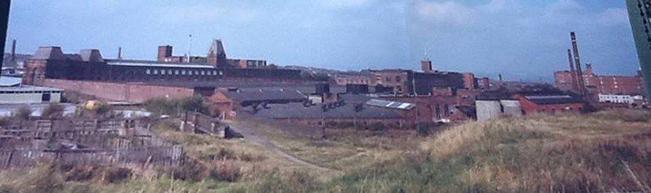
Here we are looking from above Townson's, from the Bolton side of Ellesmere Road bridge towards Daubhill Station. The empty area to the left with apparently two roads running across it had been Lomax's football ground then Evan's waste paper. The bridge that was never taken into use is 2/3 the way up on the right and the bridge at Daubhill Station is just visible with Woodbine Road to the left of it.

Signal box behind Daubhill Station, 1952. The narrow track going forward is the original (1828) route into Bolton going to the Daubhill level crossing then to Sunnyside Mills, tower and chimney visible, and stopping at Adelaide Street. The curve to the right goes under St Helens Road at the station and then follows the new (1885) route into Bolton.
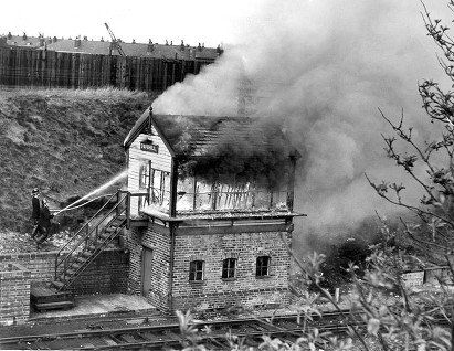
Picture by Darren Clayton 1965
By this time the signal box was just to set the points for the one train per day to Sunnyside and the six or seven trains a day using the main line. Plans were already in place for the complete of both lines but it may be that this incident brought forward the cessation of the main line use.
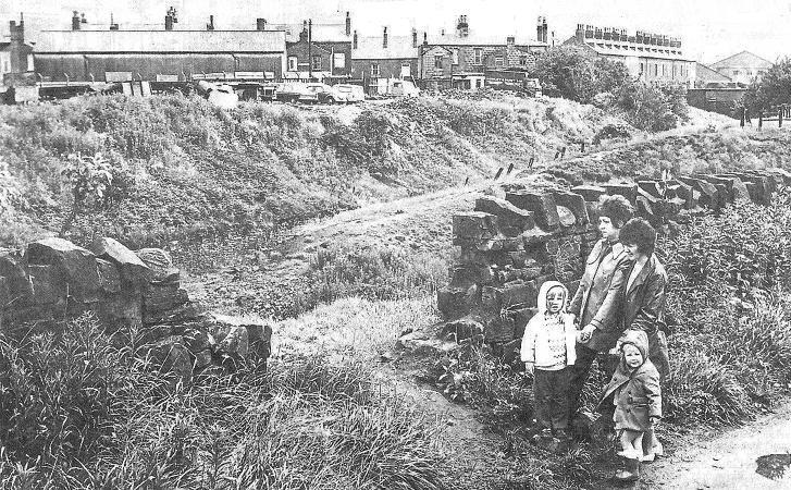
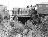
July 1972 - Picture from Bolton News - Bert Street - Collapsed wall is a danger giving access for children to the steep embankment.
The terrace of houses towards the right seen at an oblique angle is Jubilee Street. The bridge is named "Daubhill Bridge" and carries Deane Church Lane over the original (1828) Bolton to Leigh railway. The more recent alignment of the railway (1885) which went to Daubhill Station and under St Helens Road, still in use until c1965 is closer to us. A bank of earth separates the lines.
It is not possible to get a comparison picture today because buildings on what was Manfredi's ice cream factory and is now Deen (sic) Islamic Educational Centre.
On the next page we look at developments in Daubhill reflected by the 1893, 1910 and 1936 maps