Click on the buttons below to navigate through the Daubhill pages.
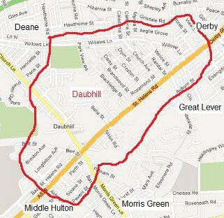
Daubhill – Dobble to the natives – is a district of Bolton two miles south-west of the town centre. Its boundaries are not precisely defined but it runs from around View Street in the east to Aldred Street in the west, and from the railway in the south to Willows Lane and Hawthorn Road at the north. It derives its name from the bed of clay which underlies much of the area but particularly where Higson’s brickworks were established in the 1880s. It has largely been shaped by the railway and the Sunnyside cotton mills.
Strictly it is bounded at the north by Willows Lane which was for a long time the boundary of Rumworth Ward. Also it runs along a ridge with streets north of it falling down to Deane Road / Wigan Road and streets south of it running down the hill to St Helens Road.
"Dobble" is also used to mean St Helens Road and the higher part of Derby Street. "On Dobble" means on that main road. "Up Dobble", if you are close to town means in the area of Daubhill; anywhere else it means further up the road than your present position. "Down Dobble" means lower down the road than your present position, even as far as town.
Just what constitutes the area of Dobble is in reality dependent on people's opinions and concepts. Some people who lived on Derby Street even below the Tivoli and in the streets either side defend with vigour their right to call themselves dobblites.
A long correspondence on Facebook reveals a strong opinion that Bridgeman Street from Adelaide Street to Goldsmith Street or High Street forms the boundary between Daubhill and Great Lever, though clearly any area south of Bridgeman Street is certainly Great Lever.
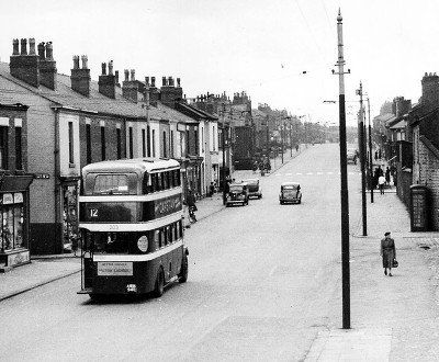
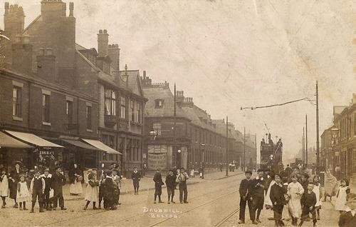
Many people talk of "the Daubhill mile" which refers to the huge number of pubs along the road up from town to Daubhill station (mentioned elsewhere). Is the beginning and end precisely defined?
Pre 1800. There is no present-day evidence on the ground for anything at Daubhill. There were scattered buildings in the area, the farm called Plane Tree, David Brow (both mentioned later) and probably most of the farms and many of the coal pits marked on the 1849 map (all disappeared long ago). The name Daubhill comes from the rise on which Park Cakes now sits and the deposit of daub (clay) behind it. Whenever foundations are dug for buildings in this area, beneath about two feet of soil is found a layer of clay also about two feet thick below which is a mixture of clay, shale and general soily and rocky material. Below this is millstone grit in alternate layers with coal seams. In some places the coal seams broke the surface, hence the ease of surface mining or shallow shaft mining for coal and the scores of pits.
Was there a particularly deep or well exposed or good quality area of clay at the point known as Daubhill (although brick making might well have been done in the area for hundreds of years, Higson’s brick-works were not built until the late 1800s), or was it simply that travellers reaching this point on their journey got the wheels of their trucks bogged down in the mire in all but the driest weather.
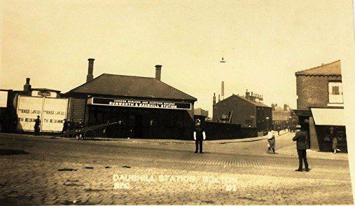
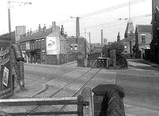
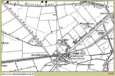
On this 1849 map we note the old spelling of Dean, Daub Hill is two words, the railway follows its original 1828 line with a level crossing, Bolton Bridge is where the railway crosses Adelaide Street, Engine House (almost certainly) houses the "stationary engine" used to cable-haul trains up the incline from High Street to here, Daub Hill Mill is roughly where the brick works was later built, there is almost no building, the whole area is fields. Daubhill Bridge is where the railway crossed Deane Church Lane. The map indicates a kink in the road to allow the bridge to be at right angles to the railway line.
www.boltonrevisited.org.uk/s-about-daubhill.html; by Jim Sant who notes that the brickworks opened 1883
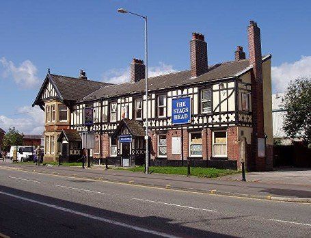
He talks of cottages on the Daub Hill built in 1815 and demolished in 1969 but the houses on his 1907 picture and clearly visible on the 1900 map are not arranged quite as the 1849 map indicates. JS web-site well worth a read . The Turnpike was probably at the cross-roads not at the pub. He makes an interesting comment about a house with a cellar – the Stag’s Head pub is marked on the 1849 map but looks much newer, so the pub on the map might be this ale house. Note that the Stag's Head closed around 2010. It is now called "The Manor House" but is not a pub.)
Daubhill as we have known it has been shaped by the cotton mills and the railway. However the cotton industry was already established and growing in Bolton. It was a cottage industry at first but Richard Arkwright built the first industrial sized cotton mill in Derbyshire in 1771 the first version of the water frame having been produced in Leigh a few years previously, Samuel Crompton (1753-1827) produced the Spinning Mule in 1779 (before his death there were over 4 million mule spindles in the area compared with some hundreds of thousands of other spinning machines, but it is well documented how little benefit Crompton got from his design whereas Arkwright who exploited the inventiveness of others became a millionaire because of his entrepreneurial skills) and rather later tenanted the top storey of a mill in King Street , John Kay (?) had a mill in Bolton at this time.
A register of 1891 has 83 cotton mills in Bolton and Little Bolton and around another 40 within 5 miles, Westhoughton, Ainsworth, Little Lever etc. There were 18 in Daubhill and the nearest part of Deane and about 10 more in Deane and Great Lever.
Raw cotton for the spinners had to come from the port of Liverpool and this was in the days of the horse and cart. The usual route was probably from Liverpool via St Helens, Parr, and Leigh to Bolton. Although a more direct route from St Helens to Bolton might have followed the present A58, it was probably the established spinning industry in Leigh which influenced the route. Roads were very poor and the industrialists, needing to get cotton and coal to the mills and the finished goods to the markets efficiently, needed improvements. The railway made a huge improvement to this transport problem.
//There would have been an alternative route from Liverpool via the Mersey and Irwell navigation scheme (early 1700s) and the Runcorn extension of the Bridgewater canal (1776) then by road or by the Manchester, Bury and Bolton canal. The Manchester Ship Canal opened in January 1894 sixty years after the direct rail link between Bolton and Liverpool.//
The next page looks at the Bolton and Saint Helens Turnpike from 1762