1849 map - the place to live
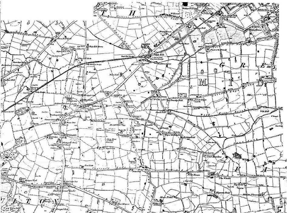
Notice how tiny Daubhill is, few houses, mostly fields, but the Stag’s Head pub is already there. Bella Street does not exist but there is Daubhill Mill at the top of what became Bella Street. There is no brick works here even though the name of Daubhill derives from the deposit of clay just above that point.
The railway follows its original line. There is no station marked. The words “engine shed” appear below “Bolton Bridge” against the unnamed road which is Adelaide Street. This is unlikely to be a depot for the locomotives but is almost certainly where the stationary engines were which powered the cable pulling trains up the steep gradient out of Bolton. The station may have been close by if indeed there was one at this time (according to Wikipedia one had been provided three years previously).
What is now St Helens Road was at this time the Bolton and St Helens Trust Turnpike. At the Daubhill crossroads is “Daubhill TP”.”TP” is “Turnpike” and is the site of one of the toll gates which must have existed every couple of miles.
What is now Morris Green Lane was then Daub Hill Lane. Deane Church Lane is spelt Dean without the “e” as is the hamlet of Dean itself.
Sapling Road is not named, but leads from Morris Green to the Sappling (sic) Field Colliery.
Notice how many collieries and coal pits there are, some within a hundred yards or less of another. “Coal pit” is likely to imply a very shallow working with just one family involved. Colliery will imply a larger business probably with mine shafts and simple lifting gear. There were no modern fully mechanised mines in the immediate neighbourhood the nearest being on Wigan Road (Victoria Colliery, recently Barton Grange Garden Centre, Bolton Garden Centre since 2013) and in the other direction Brackley Colliery(on the west edge of Little Hulton). There were a number of ventilation shafts visible until quite recently, Watergate Lane, top of Smethurst Lane, Hulton Lane, and the line of a collapsed gallery could be traced by the line of demolished or partly rebuilt houses from Sapling Road, through St Helens Road and Longfield Road and a depression across Hulton Lane Playing Fields. There is still evidence of the spoil heaps associated with this small scale mining in at least three places: in the field east of St Helens Road just beyond Whitegate farm, east of the road at the highest point of Smethurst Lane and at the top of Cow Lane.
What is still visible in 2012 that appears on the 1849 map?
Going up St Helens Road from the Daubhill crossroads: Opposite the corner marked as Rose Cottage is a Terrace marked “Rose Bank 1873”.
What is now Smethurst Lane has a different name (not readable on this map), it passes “Closes” which was Closes Farm. As its land around was built on, the farm buildings were used by car engine repairers and by Compsty's Tarmac. There is now a small new housing development with the name Closes Farm at that position on Smethurst Lane. Smethurst Lane follows the line of the lane marked “Heathland” but now binds
to the right, not the left and so reaches Plodder Lane without entering the quarry; In the 1950s the quarry extended much further east (to about the “P” of Plodder Lane) and the quarry face was clearly visible and easily accessible though the quarry was no longer worked; the area is now occupied by the Edgefold industrial estate;
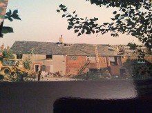
Demolition of Closes Farm - picture from Janet Hart
Culbert’s Lane is now Cuthbert Street leading on to Cow Lane, the name Top o’ th’ Cow on the map is retained to label the
concrete tank reservoir at the top of Cow Lane;
note “Over Hulton TP” presumably another Toll Gate at the top of what is Hulton Lane (though not labelled as such);
David’s Brow still exists as an old house in a modern development on Moorlands View; the lane at Garnet Fold still exists as does Horridge Fold though rebuilt with early 20th Century houses; at Plane Tree is a house which displays a sign “Plane Tree Farm and cottage” and had a date plaque from the 1600s but that is not visible now (9 April 2012) Whitegate farm, the farm house is unchanged but in 2015 a huge new cowshed and milking Parlour were built and a herd of a hundred cows now uses the fields either side of COW LANE; a house on the west of SHR is called Weigh-bridge Cottage but it is not clear if it is represented on the map; Scalyard (Scaleyard?) Lane has been renamed Plodder Lane like the lane into Farnworth from Edge Fold and slightly realigned; Newgate is now Newgate Nursery; the Red Lion Inn and the Hulton Arms are still there at Hulton Lane Ends (more recently more usually called Four Lane Ends).
Note “Dean Moor Colliery” at Top o’ th’ Cow. This area was variously called “Dean Moor” retained as the name of a small terrace of buildings at the top (west side) of Hulton Lane, “Bolton Moor” (correctly only from Sweet Green to Daubhill) and the “Great Moor” which name is still retained in “Great Moor Street”.
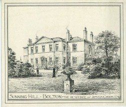
Moving east (towards town) from the Daubhill cross roads: the Stag pub was refurbished in 2010 and is now the Manor House but is no longer a public house; the line of the original railway (retained as a branch line until the 1950s) is clearly visible to the north, remnants of the level crossing gates were still to be seen until the Manor house built its new wall; the swim school occupies the line of the railway to the south east; Willows Lane follows precisely the line on the map; Sunning Hill School (built around 1880-1900) is at the position marked Sunning Hill occupied at this time by Rothwell Hall (this was the residence of the Rothwell family who owned the engineering works which bullt the “Union” locomotive for the B&L Railway mentioned earlier; there is also a street called Rothwell Street off Derby Street, nearer town). Rothwell Hall or Sunning Hill was built 1795 for William Carlile, occupied by the Rothwells 1838-1860 and bought by Joshua Crook 1861
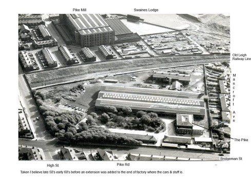
Swan Lane and High Street are unchanged. Bridgeman Street (not named) runs north-east from High Street but not yet south-west. High Street seems to mark the highest point up the hill to Deane Moor (and hence to Atherton (Chowbent), Leigh and St Helens) at which there is any amount of building. Above High Street (corner of Swan Lane) used to be the Pike Inn and behind it, running down to Bridgeman Street is Pike Road. This recalls the existence of “The Pike” another fine residence and grounds which can be seen on the 1849 map, inhabited by Robert Heywood, quilting manufacturer and Mayor of Bolton who gave Robert Heywood Park to the town. "The Pike" was in what became the southwest corner of the High Street, Bridgeman Street junction where Wm Wadsworth's lifts company was later established. Some of Wadsworths factory and offices still stand. In fact in the early days, the grounds of the Pike extended across the present line of Bridgeman Street.
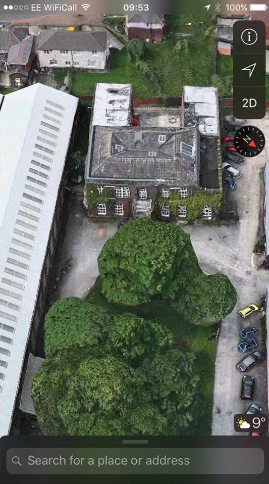
The building which housed the Wadsworth offices and which is now a pre-school group is in fact "The Pike"
Pike Mill was further down High Street on the other side of the (1885) railway.
http://bowyer.boltonmuseums.org.uk/boltonlinks.html
http://www.boltonsmayors.org.uk/heywood-r.html


Picture of Wadsworths by permission.
It was "rescued" by Sanders Paul when about to be binned.
"old railway line" is in fact the new 1885 alignment closed down by the time of the picture, not the old 1828 line.
Robert Heywood's mansion, "The Pike"
1,2,3 (C)WDC February 2020
The last picture is GoogleEarth
Click on a picture and navigate
Continuing the subject of fine houses occupied by mill owners:- A high stone wall ran alongside the road from Cannon-st. to Willows lane, behind which were pleasure gardens. In this wall, about the spot where Gibbon-st. now is, was a gate giving access to a footpath which led to two houses, one of which was occupied by the owner of the gardens. At the Willows-lane end of the wall was a well providing a water-supply for the people of Daubhill, which on early preaching plans, by the way, was printed as two words, Daub Hill.
The above was included in a description of Daubhill in 1858 according to a jubilee handbook published in 1908 quoted in The Bolton Journal and Guardian, Friday, October 23, 1936.
http://www.lan-opc.org.uk/Bolton-le-Moors/Daubhill/methodist/index.html
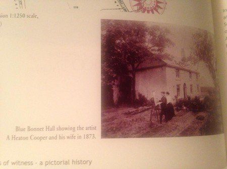
Above Daubhill station, immediately west of Smethurst Lane where St Helens Road takes a slight turn to the right, the 1849 map shows a quite substantial building to the north of St Helens Road (on what is now Hulton Lane playing fields, just called Rose Cottage but by 1893 this has been extended and adjoins Blue Bonnet Hall. This was the home of artist A Heaton Cooper and his Norwegian wife. The picture (1873) is from a booklet published to commemorate the history of St Helens Road Methodist Church (at its centenary?) and was posted on Facebook by Catherine Macleod.
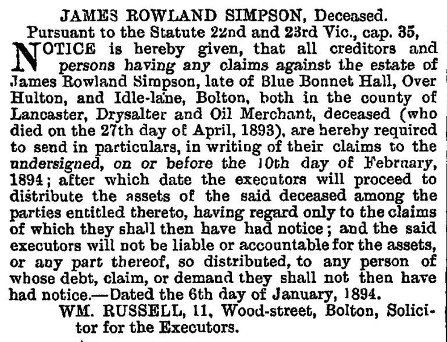
Blue Bonnet Hall was later occupied by James Rowland Simpson “a drysalter and oil merchant” whose industrial premises were in Idle Lane off Deansgate (now Central Street). The second picture is a cutting from a Bolton newspaper (1894) seeking people who might have an interest in the estate of the recently deceased Mr Simpson, posted on Facebook by Denis McCann.
Blue Bonnet Hall was demolished early in the 1900s.
On the 1849 map a stream can be seen arising close to Daubhill cross roads and crossing the fields to the west of Deane Church Lane to reach Hulton Lane where Kirkebrok Terrace now stands. After another 50 yards or so it goes underground to pass under Wigan Road and Junction Road before emerging in Deane Clough. This is the stream which appears out of a pipe in the valley between Deane church and the Kings Arms. On a later map, after Dove Mill has been built, the whole stream cannot be traced, but it can be seen to come out of the mill lodge before going across to Hulton Lane. This little stream was, a long time ago, called Kirke-brok, ie the brook by the church, and its name has been retained in Kirkebrok Terrace and Kirkebrok Road which connects Hulton Lane and Deane Church Lane). The brook had a second source near New York where the Deane School now is. This flowed between Wigan Road and Junction Road before being culverted near Smithy Hill and joining the Daubhill stream to emerge at the top of Deane Clough.
On the next page we look at Sunnyside Mills